
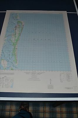
1940's Army topo map Fernandia Florida Sheet 4745 III - $50 - (Slingerlands, NY)
Back to Search Results
Posted 1 month ago
This is an Army Map Service map (AMS V747) of Fernandia (printed 1947-49, based on 1943 aerial photography) showing all of Amelia Island. nbsp; This was developed by the military as part of the effort associated with World War II and was distributed to select libraries after the war. This map is suitable for framing and guaranteed original. 22x29 1:50,000 Shipping is for US addresses and I will combine shipping. These maps have been stored flat since printing and will be shipped in a sturdy shipping tube. Look for my other similar maps of the area. I will combine shipping if you buy multiple maps. This sale is for my last copy of this map.
ADVERTISEMENT
From ebay.com - 1 month ago