
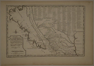
1705 Genuine Antique map Mexico, Island of California. by N. De Fer - $1,200 - (Troy, MT)
Genuine antique map "Cette Carte de CALIFORNIE et du Noveau Mexico..." by Nicholas De Fer. Famous map of California as an island, here named ‘Californias O' Carolinas', and one of the few such regional maps. The information provided by the late 17th century missionary, Kino, in about 1696, led to this mis-understanding. Keno initially mapped the lower peninsula, and thought Baja was indeed a peninsula. Nevertheless, he reported the island features which were retained in maps for many decades. Extensive legend of over 300 places. Good impression on fine paper with full margins. Separate text page included. Light age toning, a few printer's creases, as issued. Verso with library stamp, barely visible on recto in text area, still Fine. Published in Paris. Image measures 8 3/4"x 13 1/4". NOT A REPRODUCTION. All of our items are genuine antiques as described.
ADVERTISEMENT
From ebay.com - 1 month ago